Report on the 2005 Unidata Equipment Award to Western Illinois University:
New Establishment of a UNIDATA Site for Meteorological Education
Jongnam Choi
Department of Geography at Western Illinois University
1 University Circle Macomb, IL 61455
The meteorology program at Western Illinois University (WIU) continues to grow rapidly, since the meteorology major was approved in the fall of 2003; the Department of Geography has 60 meteorology majors as of fall, 2006.� There was a growing need to expand an existing meteorology laboratory and to enhance computing capacity.�
Equipment Purchased
The Unidata Equipment award enabled the Department of Geography to establish a new meteorology server.� An IDD ingest and relay server machine and external storages for system and data backups were purchased in November 2005; The server system, a Dell PowerEdge SC1420, has single Xeon 3.0 GHz processor, 4 GB of RAM, three 250 GB SATA hard drives configured as RAID5, 720 GB external storages and a DVD burner (Figure 1). The server system is currently used for data acquisition and distribution for the meteorology laboratory and other WIU communities.� The Department of Geography also provided 12 Pentium IV PC workstations in the fall of 2005 (Figure 2). These machines were configured with the Fedora Core Linux operating system to run Unidata software.� To support this plan, University Computer Support Services (UCSS) at WIU has a plan to upgrade network line to a 1 Gbps network line to the university backbone Internet network.� This high bandwidth capability will allow easy access to the meteorology server.
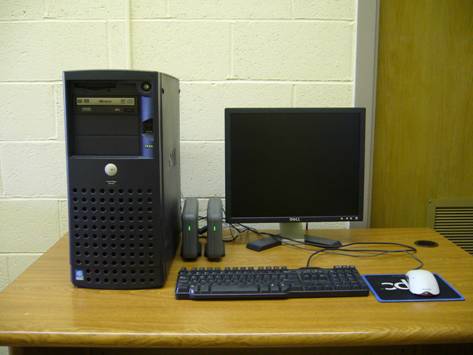
Figure 1. An IDD ingest and relay server machine and external storages.
Use of Unidata Products on Coursework
The acquisition of a Unidata LDM server enabled the department to integrate Unidata software into the existing undergraduate curriculum at all levels and to provide a high quality meteorology program for students.� Finally, the meteorology laboratory matches the departmental pedagogical needs and all meteorology major and minor students greatly benefit from the new meteorology server.
By being a Unidata community, students could access weather data including radar images, satellite images and model outputs.� In addition, new lab equipments enhanced the opportunity to implement numerical weather prediction products into an array of lab exercises by employing interactive Unidata products.� In spring 2006, GEMPAK was used as a primary visualization and analysis tool for a senior level meteorology course, Radar/Satellite Meteorology (GEOG425). Students could characterize, identify and visualize weather systems.� More importantly, the Unidata products allowed students to implement model outputs into weather analysis and forecasts.� As a new IDD node has been established, the benefit of Unidata products will also be given to other meteorology courses in the future: Dynamic Meteorology (GEOG329/429) by using vertical sounding and Synoptic Meteorology (GEOG322/422) by using IDV for the full visual enhancements of radar data.
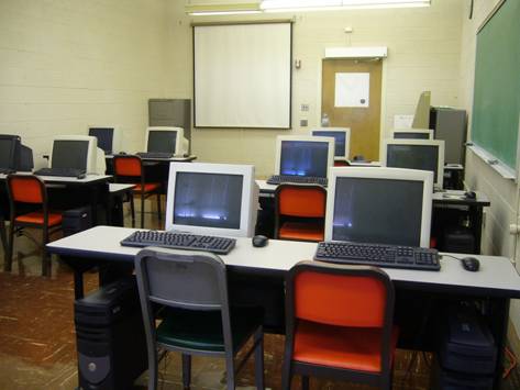
Figure 2. The meteorology laboratory at Western Illinois University.
Other Benefits from Unidata Support
The established Unidata LDM server became a most important infrastructure for the program at WIU and added new dimension and excitement into the program.� The server helps to continue to satisfy the extending need for local weather information and enable the department to continue serving as the primary source of weather information in western Illinois.� The server will be one of the most heavily used servers in the university.�
Future Plans
Current GIS laboratory in the department has includes 20 Pentium IV PC workstations.� With the assistance of University Computer Support Services (UCSS) at WIU, we plan to install Unidata products on these workstations to meet the growing need to expand existing meteorology laboratory computing capacity.
The Department of Geography has operated a local radar system for over 13 years and has collected a very high spatial and temporal resolution real-time wind data over the state Illinois for the last two years. These data has been archived on the data server. In fall 2007, we plan to provide our real-time operational radar images and the wind data to the Unidata community through the Unidata IDD network.