Hi Julien,
In reference to your 3:03PM email about loading the Default Background Maps
as Data Source, that is what I thought I did, but nothing loaded. No
errors however. A color bar came up with "missing" and "missing" as the end
points, and the display remained blank.
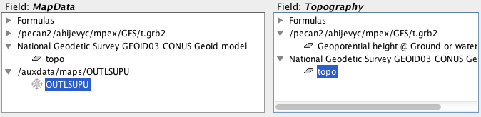
I loaded the Hi-Res US map as a Data Source and used OUTLSUPU as the
MapData. I tried Geopotential height @ Ground or water as my Topography
(see screen shot). I also tried "topo" .
[image: Inline image 1]
You're right - - using the default background maps seems to be the obvious
way to do it if I can get it to work. .
On Thu, Oct 2, 2014 at 3:03 PM, Julien Chastang <chastang@xxxxxxxx> wrote:
> David,
>
> One more obvious point that we forgot about. You can load the Default
> Background Maps as Data Sources by going to the Displays tab of the
> dashboard and selecting the Default Background Map display control. This
> will show you a list of maps. Note there is an icon or button all the way
> to the right in each row. If you hover over this button, it will say "Load
> this map as data source". Once you have done that, you can use the
> previously mentioned instructions to create a 3D map.
>
> Best,
>
> Unidata IDV Support
>
> On Thu, Oct 2, 2014 at 10:12 AM, Julien Chastang <chastang@xxxxxxxx>
> wrote:
>
>> David,
>>
>> We have some additional clarifying remarks for you and the list. You will
>> need to obtain a shape file for the region of interest. We found these to
>> be abundant on the web. Here is one for the US states:
>>
>> http://www.arcgis.com/home/item.html?id=f7f805eb65eb4ab787a0a3e1116ca7e5
>>
>> Please load the states.shp file in the Data Choosers as you would other
>> data. Also load your model data, for example 1/2 degree GFS. Once your data
>> are loaded, go to the 3D Map formula in the place described earlier and
>> choose a "Topography" display. Click "Create Display". You will see a
>> dialog where you have to enter MapData and Topography. Choose the shapefile
>> for the MapData. For the Topography, the IDV will recognize Geopotential
>> height at surface. If not, you need to pick the appropriate field from the
>> 2D fields.
>>
>> Let us know if you have additional questions or concerns.
>>
>> Best,
>>
>> Unidata IDV Support
>>
>>
>> On Wed, Oct 1, 2014 at 4:27 PM, Julien Chastang <chastang@xxxxxxxx>
>> wrote:
>>
>>> Dave,
>>>
>>> After your data are loaded, please study the IDV Dashboard, Field
>>> Selector Tab, Formulas Node (in the Data Sources), Maps, 3D Map.
>>>
>>> Also please attend the IDV workshop November 3-6. We are just down the
>>> road :-)
>>>
>>> Best,
>>>
>>> Unidata IDV Support
>>>
>>>
>>> On Wed, Oct 1, 2014 at 10:50 AM, David Ahijevych <ahijevyc@xxxxxxxx>
>>> wrote:
>>>
>>>> I'd like to render the map lines along the 3D surface, as if they were
>>>> painted on. At different viewing angles, the lines should appear stuck
>>>> to
>>>> the same surface location.
>>>>
>>>> As it is now, either my state borders are obscured by the topography or
>>>> if
>>>> I raise the vertical position of the state borders, they give the
>>>> impression of "floating" above the topography or cutting through it.
>>>>
>>>> I know you can render images on a 3D surface but can you render maps
>>>> on a
>>>> 3D surface?
>>>>
>>>> Thanks
>>>> Dave
>>>> _______________________________________________
>>>> idvusers mailing list
>>>> idvusers@xxxxxxxxxxxxxxxx
>>>> For list information, to unsubscribe, visit:
>>>> http://www.unidata.ucar.edu/mailing_lists/
>>>>
>>>
>>>
>>>
>>> --
>>> Julien Chastang
>>> Scientific Software Developer
>>> Unidata-UCAR
>>>
>>
>>
>>
>> --
>> Julien Chastang
>> Scientific Software Developer
>> Unidata-UCAR
>>
>
>
>
> --
> Julien Chastang
> Scientific Software Developer
> Unidata-UCAR
>