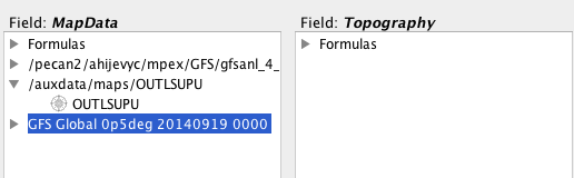
Hi,I have that problem too -- when I try a local GFS file, it doesn't
appear on the right side of the map/topo selection screen. Even when I
tried a GFS file from the Catalog it didn't show up as an option on the
right side..

[image: Inline image 1]


On Fri, Oct 3, 2014 at 1:32 PM, Murray Brown <m.brown.nsb@xxxxxxxxx> wrote:

> Julien,
>
> I can get everything to work exactly as you show it, with your files.  But
> if the topography file is a local NC file, then both topo and map show up
> on
> the left side (of the map/topo selection screen), and neither is on the
> right.  Could you please try your demo with local files.  Thanks for your
> patience.
>
> Murray
>
>
> -----Original Message-----
> From: idvusers-bounces@xxxxxxxxxxxxxxxx
> [mailto:idvusers-bounces@xxxxxxxxxxxxxxxx] On Behalf Of Julien Chastang
> Sent: Friday, October 03, 2014 12:50 PM
> To: idvusers@xxxxxxxxxxxxxxxx
> Subject: Re: [idvusers] painting map lines on 3D topography
>
> List,
>
> Several of you are reporting trouble (online and off) rendering the 3D map
> so I put together this quick screencast on how to do that:
> http://youtu.be/HoCCmYqFu6w
>
> Let us know if you have questions or concerns.
>
> Best,
>
> Unidata IDV Support
>
> On Fri, Oct 3, 2014 at 8:25 AM, Murray Brown <m.brown.nsb@xxxxxxxxx>
> wrote:
>
> > Guys,
> >
> > I'm finding that the devil is in the line " For the Topography, the
> > IDV will recognize Geopotential height at surface. If not, you need to
> > pick the appropriate field from the 2D fields."  I have a regional
> > relief grid with lat/lon coordinates, and have tried to overlay both
> > the World Borders shape (also lat/lon) and a home-made graticule shape
> > (also lat/lon).  I can easily select the FIELD: MAPDATA item (the
> > shape), but have no idea what to do for the FIELD: TOPOGRAPHY item.
> > IDV offers me a list of "formula" items, but none appears to match up
> > with my relief grid.  No matter what I select, I
> > get the error message that the units don't match up ("m or gpm").   Any
> > ideas?
> >
> > Murray
> >
> > -----Original Message-----
> > From: idvusers-bounces@xxxxxxxxxxxxxxxx
> > [mailto:idvusers-bounces@xxxxxxxxxxxxxxxx] On Behalf Of Julien
> > Chastang
> > Sent: Thursday, October 02, 2014 12:13 PM
> > To: David Ahijevych
> > Cc: idvusers
> > Subject: Re: [idvusers] painting map lines on 3D topography
> >
> > David,
> >
> > We have some additional clarifying remarks for you and the list. You
> > will need to obtain a shape file for the region of interest. We found
> > these to be abundant on the web. Here is one for the US states:
> >
> > http://www.arcgis.com/home/item.html?id=f7f805eb65eb4ab787a0a3e1116ca7
> > e5
> >
> > Please load the states.shp file in the Data Choosers as you would
> > other data. Also load your model data, for example 1/2 degree GFS.
> > Once your data are loaded, go to the 3D Map formula in the place
> > described earlier and choose a "Topography" display. Click "Create
> > Display". You will see a dialog where you have to enter MapData and
> > Topography. Choose the shapefile for the MapData. For the Topography,
> > the IDV will recognize Geopotential height at surface. If not, you
> > need to pick the appropriate field from the 2D fields.
> >
> > Let us know if you have additional questions or concerns.
> >
> > Best,
> >
> > Unidata IDV Support
> >
> >
> > On Wed, Oct 1, 2014 at 4:27 PM, Julien Chastang <chastang@xxxxxxxx>
> wrote:
> >
> > > Dave,
> > >
> > > After your data are loaded, please study the IDV Dashboard, Field
> > > Selector Tab, Formulas Node (in the Data Sources), Maps, 3D Map.
> > >
> > > Also please attend the IDV workshop November 3-6. We are just down
> > > the road :-)
> > >
> > > Best,
> > >
> > > Unidata IDV Support
> > >
> > >
> > > On Wed, Oct 1, 2014 at 10:50 AM, David Ahijevych <ahijevyc@xxxxxxxx>
> > > wrote:
> > >
> > >> I'd like to render the map lines along the 3D surface, as if they
> > >> were painted on.  At different viewing angles, the lines should
> > >> appear stuck to the same surface location.
> > >>
> > >> As it is now, either my state borders are obscured by the
> > >> topography or if I raise the vertical position of the state
> > >> borders, they give the impression of "floating" above the topography
> or
> cutting through it.
> > >>
> > >>  I know you can render images on a 3D surface but can you render
> > >> maps on a 3D surface?
> > >>
> > >> Thanks
> > >> Dave
> > >> _______________________________________________
> > >> idvusers mailing list
> > >> idvusers@xxxxxxxxxxxxxxxx
> > >> For list information, to unsubscribe, visit:
> > >> http://www.unidata.ucar.edu/mailing_lists/
> > >>
> > >
> > >
> > >
> > > --
> > > Julien Chastang
> > > Scientific Software Developer
> > > Unidata-UCAR
> > >
> >
> >
> >
> > --
> > Julien Chastang
> > Scientific Software Developer
> > Unidata-UCAR
> > _______________________________________________
> > idvusers mailing list
> > idvusers@xxxxxxxxxxxxxxxx
> > For list information, to unsubscribe, visit:
> > http://www.unidata.ucar.edu/mailing_lists/
> >
> _______________________________________________
> idvusers mailing list
> idvusers@xxxxxxxxxxxxxxxx
> For list information, to unsubscribe, visit:
> http://www.unidata.ucar.edu/mailing_lists/
>
> _______________________________________________
> idvusers mailing list
> idvusers@xxxxxxxxxxxxxxxx
> For list information, to unsubscribe, visit:
> http://www.unidata.ucar.edu/mailing_lists/
>