TDS folks,

I think the GeoTIFF response from THREDDS WCS is displaced by 1/2 grid
cell, caused by center values being written into what should be corner
values in the GeoTIFF file.

Here's what I did:
1. Request a small chunk of bathymetry (with ~ 90m grid spacing) as NetCDF3:

curl -o gom3_tiny.nc
'http://geoport.whoi.edu/thredds/wcs/bathy/gom03_v1_0?SERVICE=wcs&VERSION=1.0.0&REQUEST=GetCoverage&COVERAGE=topo&CRS=OGC:CRS84&BBOX=-71.5,39.5,-71.0,40.0&FORMAT=NetCDF3'

2. Request the same chunk as GeoTIFFfloat:
curl -o gom3_tiny.nc
'http://geoport.whoi.edu/thredds/wcs/bathy/gom03_v1_0?SERVICE=wcs&VERSION=1.0.0&REQUEST=GetCoverage&COVERAGE=topo&CRS=OGC:CRS84&BBOX=-71.5,39.5,-71.0,40.0&FORMAT=NetCDF3'

3. Drag and drop both datasets into ArcGIS and contour them at 100 m intervals.

4. Zoom in and notice that the contours do not lie on top of each
other.   The GeoTIFF contours are shifted 1/2 grid cell (~45 m) to the
north and east.

I think the reason is that coordinates values of lon and lat in NetCDF
represent the centers of the grid cell, but coordinates in GeoTIFF are
measured from the *corner* of the grid cell, not the grid cell center.

Yet if we look at the NetCDF file, the minimum lon:

$ ncks -v lon -d lon,0  gom3_tiny.nc | tail -2
lon[0]=-71.4995833333 degrees_east

and the maximum lat:

$ ncks -v lat -d lat,599 gom3_tiny.nc | tail -2
lat[599]=39.9995833333 degrees_north

are what end up getting assigned to the lower bound for lon and the
upper bound for lat in the GeoTIFF:

c:\Users\rsignell\Downloads>gdalinfo gom3_tiny.tif
Warning 1: TIFFFetchNormalTag:ASCII value for tag "Software" does not
end in null byte
Warning 1: TIFFFetchNormalTag:Incompatible type for "GDALNoDataValue";
tag ignored
Driver: GTiff/GeoTIFF
Files: gom3_tiny.tif
Size is 600, 600
Coordinate System is:
GEOGCS["WGS 84",
    DATUM["WGS_1984",
        SPHEROID["WGS 84",6378137,298.257223563,
            AUTHORITY["EPSG","7030"]],
        AUTHORITY["EPSG","6326"]],
    PRIMEM["Greenwich",0],
    UNIT["degree",0.0174532925199433],
    AUTHORITY["EPSG","4326"]]
Origin = (-71.499580383300781,39.999583333336069)
Pixel Size = (0.000833333333333,-0.000833333333332)
Metadata:
  TIFFTAG_SOFTWARE=nc2geotiff
  AREA_OR_POINT=Area
Image Structure Metadata:
  INTERLEAVE=BAND
Corner Coordinates:
Upper Left  ( -71.4995804,  39.9995833) ( 71d29'58.49"W, 39d59'58.50"N)
Lower Left  ( -71.4995804,  39.4995833) ( 71d29'58.49"W, 39d29'58.50"N)
Upper Right ( -70.9995804,  39.9995833) ( 70d59'58.49"W, 39d59'58.50"N)
Lower Right ( -70.9995804,  39.4995833) ( 70d59'58.49"W, 39d29'58.50"N)
Center      ( -71.2495804,  39.7495833) ( 71d14'58.49"W, 39d44'58.50"N)
Band 1 Block=600x1 Type=Float32, ColorInterp=Gray


I guess the good news is that not many people use the WCS response.
And the other good news is that it will take 1 minute to fix.

I'm attaching a screenshot of my ArcGIS session.

-Rich


--
Dr. Richard P. Signell   (508) 457-2229
USGS, 384 Woods Hole Rd.
Woods Hole, MA 02543-1598
Attachment:
3-14-2013 5-38-41 PM.png
Description: PNG image
thredds archives: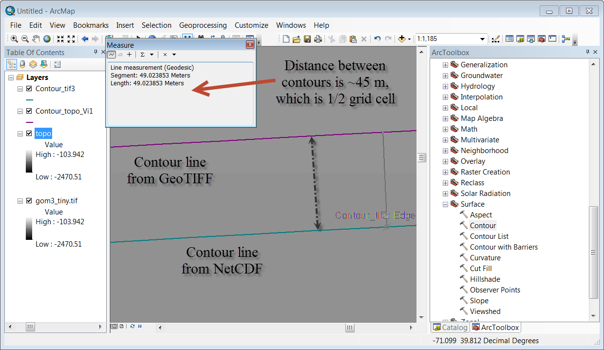