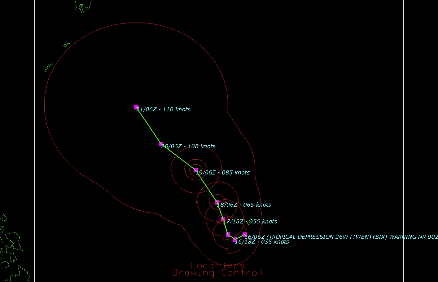
Murray,

Thanks for the clarification. I am able to reproduce the problems you see in
panel 16 (not 17). Although in your description I believe you leave out a key
detail. In step 15 after you click Create Display, you have to go back to the
dashboard > Displays Tab > Select "location" View > Display Tab and deselect
declutter. Otherwise you don't see the rings. At that point, I can reproduce
the problem.

There is probably a bug in the IDV here, but there is a simple workaround.
Strangely, selecting declutter (again!) will clean up the labels while leaving
the rings in place. See the attached figure.

Please keep us up-to-date on your progress.

Best Wishes,

Unidata IDV Support

> Good Morning,
>
> I've added the KMZ file to the webpage, and here is a link that should also
> work:
> http://marinedataliteracy.org/examples/depression_vecs_26w_twentysix_20131016T0900Z_jtwc.kmz
>
> When I use the storm track layouts, the presentations are both simplified and
> more complex.  For example, each of the windspeed polygons comes with its own
> centroid, and I get up to 3 slightly-different center icons, etc.  I'd just
> like somebody who understands how IDV handles these to take a look and
> perhaps suggest an optimal way to do it.
>
> Oh yes, and I still see IDV automatically selecting which items to display,
> based on scaling.  Is this always so?
>
> Murray
>
>
>
> -----Original Message-----
> From: Unidata IDV Support [mailto:address@hidden]
> Sent: Thursday, October 17, 2013 3:19 PM
> To: address@hidden
> Cc: address@hidden
> Subject: [IDV #QFA-384481]: Question about typhoon data
>
> Murray,
>
> The problem appears in Panel 16 not 17 with the labels overlapping or
> conflicting. Is that correct? Have you tried experimenting with different
> layers in the Storm Track control?
> We may need a better description of the problem to get to the bottom of this.
>
> Best Wishes,
>
> Unidata IDV Support
>
> > Dear IDV Folks,
> >
> > I'm really stumped by a new mystery.  I've just completed a new draft
> > exercise at 9.32 Plotting Western Pacific Typhoon
> >
> > <http://marinedataliteracy.org/ops/pac_cyclones.htm>
> >
> > Paths in Google Earth & IDV: Joint Typhoon Warning Center (JTWC).  If
> > you look at Panel 17 you see I ran aground trying to control what
> > appears with the use of an IDV locations display.  If you have time,
> > please take a look and let me know if I went as far as I can, or if
> > there's a secret to selecting specific objects to display.  The
> > "layer" coming from the JTWC is apparently a very complex suite of KML
> > items/sub-items(?).
> >
> > Murray
> >
> > Murray Brown, PhD
> > 1710 Washington St., Apt. B
> > New Smyrna Beach, Florida 32168
> > PLEASE USE ONLY THIS EMAIL --> address@hidden
> > (Home) 386.428.6367, (Cell) 386.341.0868 www.marinedataliteracy.org
> > <http://www.marinedataliteracy.org/>
> >
> >
>
>
> Ticket Details
> ===================
> Ticket ID: QFA-384481
> Department: Support IDV
> Priority: Normal
> Status: Closed
>
>
>


Ticket Details
===================
Ticket ID: QFA-384481
Department: Support IDV
Priority: Normal
Status: Closed
Attachment:
typhoon.jpg
Description: JPEG image